Local History
Map Collection
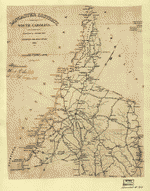
The Library houses a Map Collection that documents the early development of South Carolina, the Waxhaws, and Lancaster and Lancaster County. Most are reproductions or copies of originals.
Caroliniana Room
A map bin in the Caroliniana Room holds several maps for easy access for patrons. These include copies of city and county highway maps, the Mills' Map of Lancaster District, and the Lancaster County topographical series.
Map Cabinet
A map cabinet in the Main Library houses a wide variety of maps. These include city, county, topographical, and state maps. Visitors may request materials at the Front Desk.
Offsite Resources
-
1773 Mouzon Map
Available online at the University of Georgia's Hargrett Rare Book and Manuscripts Library -
1779, South Carolina, Universal Magazine
Available online at the University of Georgia's Hargrett Rare Book and Manuscripts Library -
1825 Lancaster District from the Mills' Atlas of South Carolina
Available online at the Geography & Map Reading Room, Library of Congress -
Sanborn Fire Insurance Maps
Lancaster County (1884 - 1926) available at the University of South Carolina -
South Carolina County Maps
Available online at the South Carolina Department of Archives and History (SCDAH)